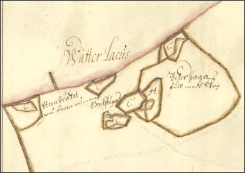
 Property surveying Wästerlösa, detail
The oldest map that lists the "Wästerlösa limestone quarry" is a survey of Västerlösa gård. The farm was the only settlement in the area for several hundred years. Although quarrying began around 1100, it was a relatively small-scale operation, apart from the quarrying of stone for Alvastra Abbey (from 1143) and Vadstena Abbey Church (1384-1430). However, there were a few back cottages in the quarry area.
The oldest map that lists the "Wästerlösa limestone quarry" is a survey of Västerlösa gård. The farm was the only settlement in the area for several hundred years. Although quarrying began around 1100, it was a relatively small-scale operation, apart from the quarrying of stone for Alvastra Abbey (from 1143) and Vadstena Abbey Church (1384-1430). However, there were a few back cottages in the quarry area.
The 17th and 18th centuries had been a quiet period in the Omberg limestone quarry. However, major changes took place after 1810 with the beginning of the so-called "heyday of quarrying".
The Göta Canal Company was founded in 1810. In order to build the locks between Motala and the Baltic Sea, the canal company rented the Omberg limestone quarry from Västerlösa gård. It was estimated that 400 tonnes were needed for each of the more than 50 locks. Material was also needed for the harbours along the canal.
However, before quarrying for the canal could begin, a harbour had to be built for the canal company's boats. The first settlement was created on old quarried limestone and brick foundations in the lake. The harbour itself was extended into the lake. It was completed around 1825 with the breakwater as the last part. The harbour was called Borghamn (after Queen Omma's Castle). The Omberg limestone quarry changed its name to Borghamn limestone quarry in 1816.
The harbour construction was difficult to solve. The Borghamn area had no naturally protected harbour. To build the harbour, timber chests were used, which were filled with stone and lowered into the water until they stood firmly on the bottom. They served as foundations and fixed points for superstructures in the water. The logs were usually assembled with salmon knots without hooks. Traditionally, the chests were timbered on the ice, then filled with stone, the ice could be chopped up, and the chest was thus lowered to the bottom.
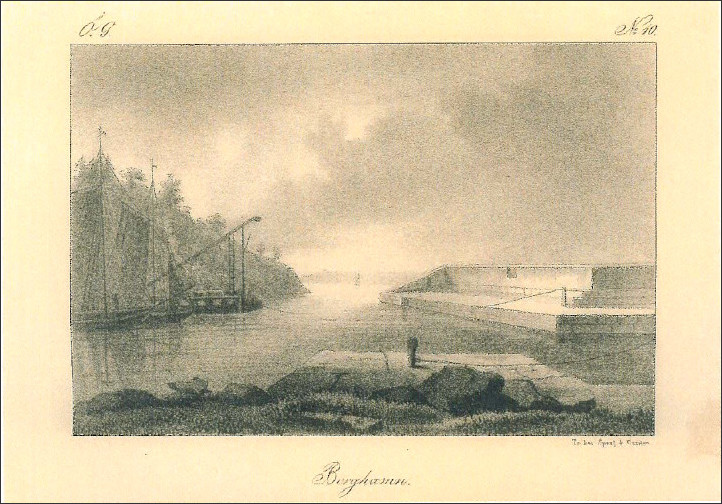 Borghamn - from "Sverige framställt i teckningar", G.H. Melin 1838-40.
In 1814, a new loading dock and two timbered stone chests were built, requiring 1576 days of labour. Work continued in 1815 when six stone chests were lowered into the harbour.
Extension and repair of the harbour was a constant problem. In 1816 a harbour pier was built. In order to protect the loading area from the western side, the stone pier in the west was created with five stone chests and bricked up with a cold wall. At the same time, the pier on the eastern side was started with two stone chests and the western pier was extended. This provided much more protection from the lake than before.
The next major expansion of the harbour took place in 1825, when the 218-foot-long breakwater was created and the pier to the northeast was completed with a cold wall. A floating dock was built for stone transport and repair work. A year later, the southern loading dock with the railway was completed. In 1828, further work was carried out, including stone cleaning in the harbour inlet, and the harbour was completed.
In 1827 the canal company terminated its lease, and Per Ludwig Ekvall, former controller of the canal company, succeeded it. At the same time, the pioneer corps was stationed in Borghamn. It is said that Ekvall earned a fortune from quarrying. In 1842 he bought the estate Attarp in Bankeryd, where - after a short time - he was murdered.
In 1819 the decision was made to build Karlsborg Fortress. The construction, which started in 1821, was expected to take 10 years, but after 25 years, half of it had not been completed. Deliveries of limestone from Borghamn started already in 1821, but the final defence (1844-1866) would be the big challenge.
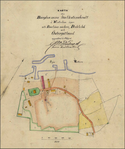
In 1842, the state bought the limestone quarry with its buildings. A detailed measurement and description was made for tax purposes.
The Crown Labour Corps was stationed in Borghamn and a work station (prison for convicts) was established. It housed around 100-120 enlisted soldiers who had been convicted of minor offences, vagrants and lifetime prisoners and served their sentences or capitulation periods.
The settlement was built on old broken limestone bedrock and bricked bedrock in the lake, filled with limestone gravel. The area outside the old shoreline is coloured red. Around the dwelling house ("Kommendanten") a garden had been laid out of applied soil. The limestone quarry has been partly blasted under the surface of the lake and filled with water. The area quarried was actually quite small. The major changes would begin a few years later.
Buildings in use in 1846: Residential house, cookhouse, three smaller barracks, hospital, infirmary and NCO's quarters, officers' quarters and prison, stone planing house, water pump, two workshops, ox stables, blacksmith's shop and weigh house. There was also an earth cellar south of the dwelling house and a lime kiln on the eastern bank.
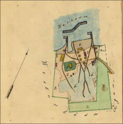 Borghamn 1849-51
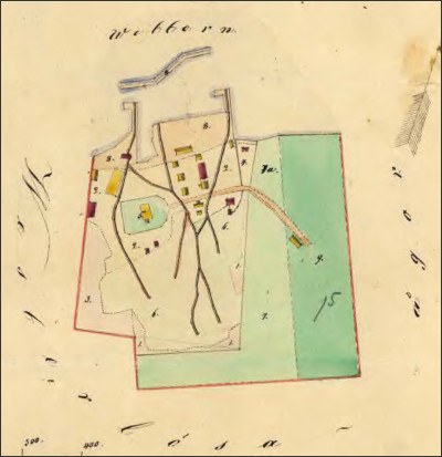 Borghamn 1853
 Borghamn 1869
The images above show the development of the settlement, limestone quarry and harbour between 1849 and 1869. Despite the arrival of the Crown Labour Corps in 1842, the settlement changed relatively slowly. The first drawings for new buildings are dated 1850 (barracks proposal corresponding to the smaller southern part of the wing, which is now called "Omma") and 1852 ("old barracks", "Långholmen", "Omma"). The so-called "old barracks" with three bedrooms for 132 people was built in the 1850s and replaced the three smaller houses on the same site, i.e. to the west of the central settlement.
In 1860, the new hospital was built in the south-eastern part with the "Fahnenjunker's" apartment and the provisions depot, arrest cells and mangle room on the ground floor (the "small annex", the hostel's "Colonel" and today's "Housemother"). In the 1860s, the officers' mess (later the tourist hotel, i.e. the Omberg guesthouse) was also built on the hill in the south-western part of the complex.
In the second half of the 19th century, the development of the harbour to the east began with the so-called Bondbryggan (farmer's pier). The eastern part of the harbour was intended for the transport of grain to Västra Götaland and the inflow of timber from Omberg. The timber was delivered to the former sawmill at Kastanjeallén and Skedet's sawmill.
In the picture above from 1874 you can see Borghamn in relation to Västerlösa and the local roads: Göta kanalbolagets old harbour entrance, the old Borghamnsvägen (Rogslösa-Västerlösa), Långebergsvägen from Västerlösa over Omberg towards Höje/Stocklycke and Skedagatan. The buildings along the lower part of Skedagatan are no longer there.
The Fortress Museum's map shows the development of Borghamn's limestone quarry in three stages from 1852 to 1869 to 1884 with extensions to the south and east. Future new harbour entrance via Borghamnsvägen and the canal company's old entrance, which was quarried away.
The expansion of the harbour to the east is clearly shown. This area was also extended into the lake. The buildings after a plan drawn up in the 1880s.
To be continued.
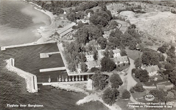
A greeting from Borghamn. The postcard shows old Borghamn from the air and was taken before 1961.
The Vadstena Folkhögskola Association founded the country housekeeping school in 1923 on the former premises of Kronoarbetskåren. The barracks became classrooms, and the large annex was turned into a sewing and weaving room. On the upper floor of the barracks a teacher's flat and later a headmaster's flat were created. The students were housed in the former commander's house and other buildings.
In 1972 the housekeeping school was renamed Borghamnskola, ten years later the boarding school was taken over by the municipality of Vadstena. In 1992 the focus of the school shifted to the children's and leisure programme. Five years later the school moved to Vadstena (Vadstena Gymnasiet). From 1997 to 2017 a youth hostel was operated on the premises. Today the complex belongs to Borghamn Strand.
The picture shows old Borghamn from the air, long before the great changes of 1972, when Norra Sjövägen was given a direct connection to Borghamnsvägen through the filled quarry. The extension of the quarry to the east is clearly visible. In the picture the entrance to the harbour starts at the chestnut alley and leads from there directly to the "Kommendanten".
The house with the gymnastics hall ("Leutnant") had not yet been built. However, the old quarry from 1842, which is partly still preserved today, is clearly visible.
The fishing boats are neatly lined up next to each other. At that time there was hardly any trace of leisure boats.
Take a guided tour ("Sten födde Borghamn") and discover the old Borghamn and Borghamn limestone quarry, Bocka churchyard. Read more on Kulturguidningar i Dal's guided tour programme.
More picture postcards from Borghamn can be found on Greetings from Borghamn.